This website uses cookies to ensure you get the best experience on our website. Learn more
Ka Khoh Ramhah

Ka Khoh Ramhah


Address:
Mawsmai - Shella Road, Cherrapunjee, India
Mawsmai - Shella Road, Cherrapunjee, India
Attraction Location
Ka Khoh Ramhah Videos

Khoh Ramhah II Northeast India II Cherrapunjee IISohra II gopro7black
Khoh Ramhah or Mortrop is a giant conical shaped single rock situated nearly 64 km away from the capital city of Meghalaya, SHILLONG, the Scotland of Eastits accessible by road and there is no derth of home stays and eatery around.
do like and comment
Music:


TravelExpedia - The Legend of Ka Khoh Ramhah
Travelling and exploration, comparison of places and architecture, etc for educative purposes.
Dainthlen Falls in Cherrapunji, Meghalaya
Just before reaching Sohra, a road to the right, leads one to the falls which is 5 kms away. The waterfall derives its name from a Thlen or a snake of gigantic size which dwelt in a cave. Legend has it that the people destroyed the snake in order to rid themselves of its reign of terror. Adjacent to the very spot where the Thlen was slaughtered lies the Dain-thlen Waterfalls. Natural rock carvings of the episode draw visitors to see the image of the Thlen, the symbol of greed, corruption and evil.Source: megtourism.gov.in/waterfalls.html
This footage is part of the professionally-shot broadcast stock footage archive of Wilderness Films India Ltd., the largest collection of HD imagery from South Asia. The collection comprises of 100, 000+ hours of high quality broadcast imagery, mostly shot on HDCAM / SR 1080i High Definition, Alexa, SR, XDCAM and 4K. Write to us for licensing this footage on a broadcast format, for use in your production! We are happy to be commissioned to film for you or else provide you with broadcast crewing and production solutions across South Asia. We pride ourselves in bringing the best of India and South Asia to the world...
Please subscribe to our channel wildfilmsindia on Youtube for a steady stream of videos from across India. Also, visit and enjoy your journey across India at clipahoy.com , India's first video-based social networking experience!
Reach us at rupindang [at] gmail [dot] com and admin@wildfilmsindia.com

Khoh Ramhah, also known as Pillar Rock,Sohra(Cherrapunji).
Described by some as Shivling, this is a natural rock formation.Please like the video and subscribe to my channel by clicking on the R icon in the video.
Khoh Ramhah, Sohra, Meghalaya
Khoh Ramhah popularly known as Pillar rock located in the East Khasi Hills district in Sohra, Meghalaya state of India. For more details click on -**JOIN US ON**
Facebook --
Google + --
Twitter --
LinkedIn --

Dr Ajay Kumar Ojha Romancing with Nature at Ka Khoh Ramhah Cherrapunjee Meghalaya
Video uploaded by Dr Ajay Kumar OjhaThis video clip is of Ka Khoh Ramhah Point Cherrapunjee (Sohra) Meghalaya India where Nature is in its purest & most beautiful form overlooking Bangladesh. This is also known as Pillar Rock Point or Mot Throp View . The clouds ascending from the plains of Bangladesh and passing through the rocks add beauty and aura to this place.In this clip Dr Ajay Kumar Ojha is seen romancing with the nature at this beautiful point - Peaceful Pollution-free Point.

Giant Single Rock Shiva Linga at Motrop (Khoh Ramhah) Cherrapunjee - Meghalaya Tourism Video
Ka Khoh Ramhah or Motrop in Cherrapunjee, Meghalaya is an imposing single rock formation in the shape of a giant cone or Shiva Linga. It lies in close proximity to two other very similar rocks standing like a pair of giant sentinels. During the heavy monsoons, water flows between the two rocks and the cascading waterfall presents a breathtaking sight. This is a popular picnic spot. You will also have a great view of Bangladesh Sylhet Plains from here.
Sohra market in Cherrapunji
The magic of market day at Sohra/Cherrapunji is something to be experienced by a tourist. It is not just a market place to buy and sell products but it is a socializing event.Cherrapunji was initially named as Sohra, pronounced as Churra by the British. But however now again the government of Meghalaya is decided to refer Cherrapunji by its original name. There are evidences for this place being under the British for a period like one can see the monument of David Scott who was the British Administrator in NE India, 1802–31.Though the place receive rainfall throughout the year irrigation is not possible here because of heavy rain the topsoil is washed away and as a result of this you can see encroachment of the people into the forest.
The word Cherrapunji means 'land of oranges'. Despite perennial rainfall, Cherrapunji faces an acute water shortage and the inhabitants often have to trek for miles to obtain potable water. The Meghalaya state government has renamed Cherrapunjee back to its original name, Sohra. The history of the Khasis – the inhabitants of Cherrapunji – may be traced from the early part of the 16th century. Between the 16th and 18th centuries these people were ruled by the 'Syiems (rajas or chiefs) of Khyriem' in the Khasi hills. The Khasi hills came under British authority in 1883 with the submission of the last of the important syiems, Tirot Singh.
Cherrapunjee’s original name is ‘Sohrapoonjee’. ‘Poonjee’ refers to the head village where the seat of power of the Chieftain is. The English who ruled over this place from 1830-1947 could not pronounce ‘Sohrapoonjee’ correctly and as was typical of them named it ‘Cherrapunjee’. People who do not know the origin of the name also spell Cherrapunjee as ‘Cherrapunji’. Popular usage is Cherrapunjee, while we the people of the place continue to call it ‘Sohra’ only. Some old colonial period writings refer it as ‘Chirra’ too.
source: sohra.gov.in/sohraprofile.html
To SUBSCRIBE click the below link:
Like & Follow Us on:
Facebook:
Twitter:
Website:
This footage is part of the professionally-shot broadcast stock footage archive of Wilderness Films India Ltd., the largest collection of HD imagery from South Asia. The collection comprises of 100, 000+ hours of high quality broadcast imagery, mostly shot on HDCAM / SR 1080i High Definition, Alexa, SR, XDCAM and 4K. Write to us for licensing this footage on a broadcast format, for use in your production! We are happy to be commissioned to film for you or else provide you with broadcast crewing and production solutions across South Asia. We pride ourselves in bringing the best of India and South Asia to the world...
Please subscribe to our channel wildfilmsindia on Youtube for a steady stream of videos from across India. Also, visit and enjoy your journey across India at clipahoy.com , India's first video-based social networking experience!
Reach us at rupindang [at] gmail [dot] com and admin@wildfilmsindia.com
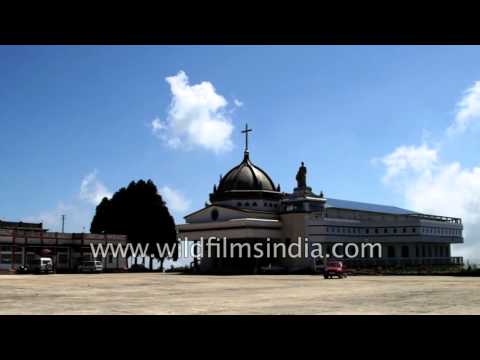
Sohra Don Bosco Shrine in Cherrapunjee, Meghalaya
Don Bosco Shrine located at Maraikaphon, Sohra. This is the only Shrine in all India dedicated to Don Bosco.Cherrapunji stands out as the centre of Khasi culture and society. The numerous neoliths and megaliths (known in the Khasi language as ‘mawbynna’) honouring the dead, speak volumes on the bygone splendour of the kingdom. The innumerable Khasi songs and folklore which have their origin and setting in Cherrapunji point to a chequered history of culture, art, literature, dance and religion. Even today, the social fabric which constitutes Khasi life look to Cherrapunji for inspiration and guidance. If one would discover all that is best in the Khasi culture and tradition, one must turn to Cherrapunji.
Christianity was first brought to Sohra kingdom in 1813 by Krishna Chanora Pal, a missionary from Serampore, sent by William Carey. Duwan and Anna, it is believed were the first Khasi converts to Christianity. Chandra Pal returned to Serampore after six months and only in 1832 did the next missionary, Alexander B. Lesh, arrive in Cherrapunji, where he took up residence, the first missionary to do so. In the following year Cherrapunji became the British administrative capital of Assam. Lesh opened schools in Cherrapunji, Mawsmai and Mawmluh, but in 1838 heleft the Khasi Hills, thus ending the Baptist presence there. Though the Baptist did not stay long, their contribution was lasting. As early as 1874 William Carey brought out the “Khashee New Testament”, using the Bengali script as Khasi had yet not script of its own.In 1841 Thomas Jones and his wife, Presbyterian missionary arrived in Cherrapunji. It was Jones who adapted the Roman script to the Khasi language, which was till then unwritten. In 1891 the Presbyterians brought out the Khasi Bible.
Source : sohra.gov.in
To SUBSCRIBE click the below link:
Like & Follow Us on:
Facebook:
Twitter:
Website:
This footage is part of the professionally-shot broadcast stock footage archive of Wilderness Films India Ltd., the largest collection of HD imagery from South Asia. The collection comprises of 100, 000+ hours of high quality broadcast imagery, mostly shot on HDCAM / SR 1080i High Definition, Alexa, SR, XDCAM and 4K. Write to us for licensing this footage on a broadcast format, for use in your production! We are happy to be commissioned to film for you or else provide you with broadcast crewing and production solutions across South Asia. We pride ourselves in bringing the best of India and South Asia to the world...
Please subscribe to our channel wildfilmsindia on Youtube for a steady stream of videos from across India. Also, visit and enjoy your journey across India at clipahoy.com , India's first video-based social networking experience!
Reach us at rupindang [at] gmail [dot] com and admin@wildfilmsindia.com

Nohkalikai Falls in Cherapunji - Tallest plunge waterfall in India
Nohkalikai Falls is the tallest plunge waterfall in India with a height of 1100 feet located near Cherrapunji, one of the wettest places on Earth. Nohkalikai Falls are fed by the rainwater collected on the summit of comparatively small plateau and decrease in power during the dry season in December - February. Below the falls there has formed a plunge pool with unusual green colored water.Cherapunji also called Sohra, Cherrapunjee and Charrapunji, is a town in East Khasi Hills district in the Indian state of Meghalaya. It is credited as being the wettest place on Earth. However, nearby Mawsynram has more rainfall nowadays, and both are surpassed by Lloró, Colombia. Today, climatic changes have edged Cherrapunji out of the topmost 'wet' slot, but it still retains its pristine beauty, its unusual facets, the perpetual clouds, and the perpetual mists. Appropriately, Cherrapunji lies in the heart of the State of Meghalaya-the abode of clouds. It is the traditional capital of a hima which is a Khasi tribal chieftainship constituting a petty state known as Sohra or Churra. High above misty valleys and foaming rivers, ensconced in swirling clouds and perched on an escarpment, lies Cherrapunji (4,500 feet).
Cherrapunji receives rains from the Bay of Bengal arm of the Indian summer monsoon. The monsoon clouds fly unhindered over the plains of Bangladesh for about 400 km. Thereafter, they hit the Khasi Hills which rise abruptly from the plains to a height of about 1370 m above mean sea level within 2 to 5 km. The winds push the rain clouds through these gorges and up the steep slopes. The rapid ascent of the clouds into the upper atmosphere hastens the cooling and helps vapours to condense. Most of Cherrapunji's rain is the result of air being lifted as a large body of water vapour. The extreme amount of rainfall at Cherrapunji is perhaps the best-known feature of orographic rain in northeast India.
The home of enterprising Khasi clans, Cherrapunji's place in the Guinness Book of Records is not its only claim to fame. Along with falls lesser in height but no less alluring, the spectacular, cascading 1,035-ft-high Mawsmai Falls-the fourth highest in India-lie just a few kilometers beyond Cherrapunji. Close by is situated a fascinating labyrinth of underground passages beneath age-old caves-a veritable dream for amateur explorers. Elsewhere around Cherrapunji, Khasi monoliths (stones in memory of their ancestors) lie dotted around-a vague reminder of the forests of Bastar. Cherrapunji has several comfortable private hotels. Staying at the Circuit House and the Dak Bungalow require prior permission from the administration. Cherrapunji is 58 km from Shillong, the capital of Meghalaya. A steep motorable road, almost perpetually bathed in mist as it climbs upwards on the last lap, leads up to Cherrapunji. Buses and taxis ply to Cherrapunji from Shillong.
Source: wikipedia.org &
This footage is part of the professionally-shot broadcast stock footage archive of Wilderness Films India Ltd., the largest collection of HD imagery from South Asia. The Wilderness Films India collection comprises of tens of thousands of hours of high quality broadcast imagery, mostly shot on HDCAM 1080i High Definition, HDV and XDCAM. Write to us for licensing this footage on a broadcast format, for use in your production! We are happy to be commissioned to film for you or else provide you with broadcast crewing and production solutions across South Asia. We pride ourselves in bringing the best of India and South Asia to the world... Reach us at rupindang [at] gmail [dot] com and admin@wildfilmsindia.com.

Nohkalikai Falls Sohra

Dainthlen Falls- SOHRA/CHERAPUNJEE
#dainthlen#dainthlenfalls
#sohra
#cherapunjee
#cherapunji
Dain Thlen Falls is also one of the famous falls. Many tourists flock the falls especially as it has an interesting legend associated with it. The waterfall derives its name from a Thlen (Khasi word for Python). As per the legend, people decided to rid themselves of evil, captured the Thlen and killed it at the wide flat rock over-looking the waterfall. Adjacent to the very spot where the Thlen was slaughtered lies the Dain-thlen Waterfalls. Natural rock carvings of the episode draw visitors to see the image of the Thlen, the symbol of greed, corruption and evil.
Track: Defqwop - Awakening [NCS Release]
Music provided by NoCopyrightSounds.
Watch:
Free Download / Stream:
wadogkgre,Bhaitbari,West Garo hills
Nohsngithiang Falls
Eco Park
Khoh Ramhah
Killapara memorial,Dalu West Garo hills
Tura District museum
Balpakaram national park
Siju cave, Dobakol
chisobibra
pa togan N.Sangma, park
Rongbang waterfall
songkalwari fish sanctuary
daribokgre, nokrek
Waribok
maa charantala temple
dachi lake
tree house resorts
Chandi Dare
Chibragre
PelgaFalls
Pelgawari
Pelgadare
Bhaitbari
Matrong Dare Baghmara south Garo Hills
Rangapani
Naka-Chikong
NengkongTetengkol
Imilchang Dare
Kodaldhowa Lake
Chenga-benga Lake
Rongmeram falls
Dopgre
durabanda falls
bandagre falls
Ranganma Dare
Ranganma waterfalls,
Shallang
Sundi waterfalls
Chandi Dare
Chibok Dare(Falls)| Garo Hills, Meghalaya|
Mesak Dare
Sundi dare at Mangsang
Chandigre tourist resort,tura
Aminda rangsa,Amindagre Village,Gambegre
Williamnagar
Ampati
Mendipathar
Resubelpara
Baghmara
Tura
mahatmagandhipark
Lady Hydari Park
Wards Lake
Shillong Golf Course
Motphran
Shillong Peak:
Capt. Williamson Sangma State Museum
Don Bosco Centre for Indigenous Cultures
Entomological Museum
Air Force Museum at Upper Shillong
Forest Museum in Lady Hydari Park
Rhino Heritage Museum at Shillong
Zoological Museum in Risa Colony
Anthropological museum at Mawblei
Botanical Museum at 4th Furlong
Arunachal Museum at the Cantonment Area
State Museum,
Mawsawa falls
Arwah Cave, Cheerapunjee
Garden of Caves, Laitmawsiang
Cathedral of Mary Help of Christians
Bishop and Beadon Falls
Spread Eagle Falls
Sweet Falls:Kshaid Dain Thlen Falls
Crinoline Falls
Laitlum Canyon, the end of the hills
moopun falls
Wahkhen Mawryngkhang
U Mawryngkhang king of Stone
Shillong Airport
Beljek Airport,Kyllang Rock,shillong bypass,
Wei sawdong
Bazar India shopping mall Tura
Tura shopping mall
Ampati College
bitasing market
kharugaon
Ampati super market
Kamakhya Temple,
Mankachar,Assam
Mirzumla Dargah/Mirzumla maszid
Tukreswari Temple in Goalpara
Sri Surya Pahar,Goalpara
Naranarayan Setu
Jogighopa bridge
Umananda Temple,
Kamakhya Temple,
Guwahati Zoo,
Assam state Museum,
ISKCON Guwahati,
Pobitora wildlife sanctuary,
Basistha ashram
Guwahati Planetarium
Bhubaneswari Temple,
Kaziranga National Park,
Pua Mecca Hajo,
Manas National Park,
Dipor bil/deepar beel
Regional Science Center Guwahati
Fancy Bazar
Navagraha Temple
shrimanta shankaradeva kalakshetra
Sukreshwar Temple,
Dighalipukhari lake
Ugra Tara temple
Saraighat bridge
Nehru Park guwahati
Purva Tirupati Shri Balaji temple
The Maati Centre guwahati
Temples of Hajo
Accoland guwahati
Dreamland amushland park
Sildubi waterfalls
malangkona waterfalls
Sradhanjali Kanan
Madan Kamdev guwahati
Dr. Bhupen Hazarika Samadhi Khetra Memorial
Treasured Wheels guwahati
Janardana Temple Guwahati
Sri Surya Pahar goalpara
Uzan Bazar Fish Market
Panacea- The Village, Sonapur, Assam
Brahmaputra River Cruise
Sualkuchi
Sri Aswaklanta Temple guwahati
Majuli
Nameri national park
Dibru Saikhowa National Park
Orang National park
Mayong, 'the land of black magic
Kolia Bhomora Setu, Tezpur
Naranarayan Setu, Jogighopa
New Saraighat Bridge, Guwahati
Bogibeel Bridge
Dhola Sadiya Bridge, Dhola Sadiya
paltan bazar guwahati
ISBT Guwahati
City Centre Mall, guwahati
ROODRAKSH MALL,Guwahati
Central Mall,Guwahati
The Hub Mall,Guwahati
Sohum Shoppe,Guwahati
Reliance Trends, guwahati
Vishal Mega mart, Guwahati
Pantaloons Guwahati
Big bazaar Guwahati
FBB Guwahati
V2 Guwahati
Taj Vivanta hotel guwahati
Vivanta Guwahati, Assam
Radisson Blu Hotel Guwahati
The Lily Hotel, Guwahati
Hotel Shoolin Grand,Guwahati
Novotel Guwahati GS Road
Hotel Royale de Casa, guwahati
Hotel Nandan,guwahati
Hotel Atithi,Guwahati
Silchar
Dibrugarh
Jorhat
Nagaon (Nowgong)
Abhayapuri town
Bhelughat,Karbi Anglong
Panimur ( Koka ),mrangso of Dima Hasao district, Assam
Kakochang Waterfall
Kangthilangso Waterfall ,Kanthi in Karbi Anglong
Tegheria Falls,Guwahati
Chapnalla,Nagaon District

Mawsawa Falls Cherrapunjee Meghalaya India
Mawsawa Falls Cherrapunjee Meghalaya IndiaMawsawa Falls | Mawsawa Falls Meghalaya | Mawsawa Falls Laitryngew Sohra Cherrapunjee Meghalaya India | Hidden Falls
This is an extremely nice hidden hidden falls near Laitryngew, Sohra, Cherrapunjee, at Meghalaya, in India.

KhohRamhah Sohra

Snake waterfall | Dainthlen waterfall of Cherrapunji | One in Top Ten Waterfalls of India
This waterfall derive its name from Thlen or snake of gigantic size which dwelt in a cave.
Exploring Sohra (Cherrapunjee) - Lyngksair Falls
This place is out of the way and requires a bit of trekking/cycling to get there. It is tucked in some remote corner and is overgrown with foliage. You can even miss the path leading to the falls. It is a sight to behold - two huge waterfalls and a clear blue pool. Not for the faint-hearted.
Cherrapunji | The Land Of Rains | places to visit in cherrapunji
Shop for Best Women's Clothing, Shoes, Jewelry, Watches & Handbags : Amazon.in ☛►To SUBSCRIBE HERE :-
The name cherrapunji which means 'land of oranges' was first used by tourists from other parts of India. It receives one of the heaviest rainfall in India. Famous for its waterfalls and landscape beauties. places to visit in cherrapunji are:
Eco park, Double-decker-living-root-bridge, Ka-khoh-ramhah, Mawlynnong waterfall, Mawsmai caves road, Nohkalikai falls.
Note. I Am Hereby Declare That All images Use To Make This Video is From Google Search google.com . I use Google Advanced Search To Collect Those images, Usage Rights: free to USE, SHARE or MODIFY. Music are taken from YouTube Audio Library.

KYLLANG ROCK MEGHALAYA

Trek to Nohkalikai Falls - Meghalaya | Tallest Waterfall in India | GoPro HD
So it was just another morning in cherrapunji,roaming around seven sisters fall and then we saw an ice-cream shop and decided to take a break. The ice-cream vender told us that you guys can go for a trek to Nohkalikai Fall,it is the tallest waterfall in India. We liked the name and got a cab to the fall and when we reached the fall we saw there was a view point from where everybody was enjoying the view but something was not right we were not here for this. So i decided to search a way to get to the fall. And then we found a staircase that can lead us to the bottom of the fall but those stairs ended up halfway and people saying that this way is going no where but we continued our trek and after 2-3 river crossings and hard trek though the dense forest Yess We reached the Giantt Nohkalikai Falls. It was amazing and was a different feeling to get there.Thankyou
Connect me on
Fb profile link -
Instagram ID - mayunkk
Page link -
Video By - Mayank Pandey
More Attractions in Cherrapunjee
-
Arwah Cave
-
 Daiñthlen Falls
-
 Don Bosco Shrine
-
Double Decker Living Root Bridge
-
Duwan Sing Syiem View Point
-
 Eco Park
-
 Ka Kper Syiem Sohra
-
 Khasi monoliths
-
Kynrem Falls
-
Mawkdok Dympep Valley
-
Mawmluh Cave
-
Mawsmai Cave
-
Nohkalikai Falls
-
Nohsngithiang Falls
-
Nongsawlia Church
-
Nongsawlia Presbyterian Church
-
Sa-I-Mika Park
-
Seven Sisters Falls
-
Thangkharang Park
-
Wah Kaba Falls


