This website uses cookies to ensure you get the best experience on our website. Learn more
The Best Attractions In Bhabhua

Kaimur district is one of the thirty-eight districts of Bihar state, India. The district headquarters are located at Bhabua. Before 1991, it was part of Rohtas District, Bihar. The district occupies an area of 3363 km² and has a population of 1,626,384 with the rank of 307th in the country. The district has a Literacy rate of 69.34% . Kaimur district is a part of Patna division. It is the westernmost district of Bihar, western point of Bihar called Chand is situated on the Bhabua-Chandauli road. The district has 18 Colleges, 58 High Schools, 146 Middle Schools and 763 Primary Schools. The district has a total no. of 1699 villages. The district also ha...
Continue reading...
From Wikipedia, the free encyclopedia.
Continue reading...
From Wikipedia, the free encyclopedia.
The Best Attractions In Bhabhua
-
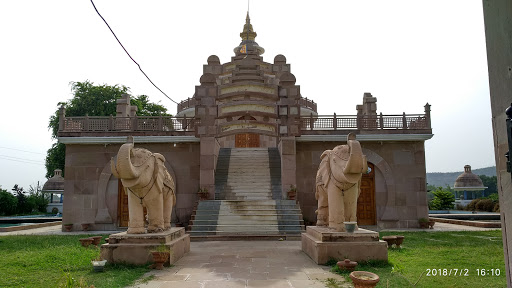
4. Maa Tara Chandi Temple Sasaram
Maa Tara Chandi Temple is a Hindu temple dedicated to Maa Shakti or Maa Durga, located in Sasaram, Bihar, India. It is one of the 52 Shakti Peetha.
From Wikipedia, the free encyclopedia. -
5. Tomb of Sher Shah Suri Sasaram
The tomb of Sher Shah Suri is in the Sasaram town of Bihar state, India. The tomb was built in memory of Emperor Sher Shah Suri, a Pathan from Bihar who defeated the Mughal Empire and founded the Suri Empire in northern India. He died in an accidental gunpowder explosion in the fort of Kalinjar on 10th day of Rabi' al-awwal, A.H. 952 or 13 May 1545 AD.
From Wikipedia, the free encyclopedia. -
6. Dhua Kund Sasaram
The Dhua Kund are a pair of waterfalls situated in the city of Sasaram. These two waterfalls have been utilised as a hydroelectricity source with the capacity to generate 50–100 MW of electricity.
From Wikipedia, the free encyclopedia.


Bhabhua Videos

Kaimur wildlife Sanctuary
Kaimur wildlife SanctuaryMahadev

Kaimur District || जिला कैमूर || in Bihar
Kaimur district is one of the thirty eight districts of Bihar state India.
मुंडेश्वरी मंदिर का हैरान कर देने वाला रहस्य | Mundeshwari temple Bihar|| mystery of mundeshwari
Namskar mitro ...Mundeshwari dham ka chukane vala video samne mai lekar aya hu jo ki kaphi durlabh hai..मुंडेश्वरी मंदिर का हैरान कर देने वाला रहस्य | Mundeshwari temple Bihar
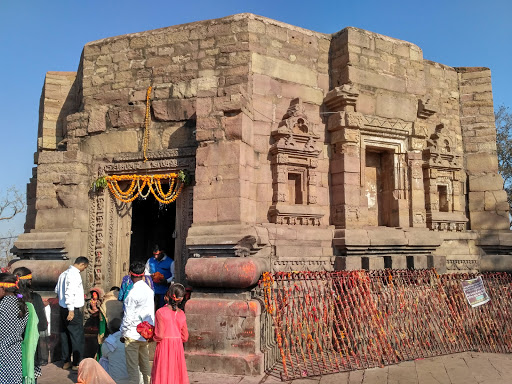
The Mundeshwari Devi Temple (also spelled as Mundesvari) is located at Kaura in Kaimur district in the state of Bihar, India on the Mundeshwari Hills. It is an ancient temple dedicated to the worship of Lord Shiva and Shakti and is considered one of the oldest Hindu temples in Bihar. It is also considered as the 'oldest functional' temple of world.
Mundeshwari Temple Address:
Mundeshwari Dham Road, Bhabua, Bihar 821103
Note: Mundeswari temple is located 10 kilometres from the small town of Bhabhua, 120 kilometres from Varanasi and 175 kilometres from Patna in Bihar. This temple, one of the earliest specimens of Nagara temple architecture in Bihar, situated at a village Ramgarh on a 600 feet high hill.
How To Reach Mundeswari Temple, Bihar
By Air
There is no independent airport in Kaimur... If you want to come here by airways, then you need to connect through Varanasi Airport, which is the nearest airport.
By Train
Mohania is the only major railway junction of district . Commonly the station is known as Bhabua Road on the Howrah-New Delhi Grand Card located in the Mughalsarai region. A large number of trains connect the city to almost all states and important cities of the country.
By Road
Kaimur is 200kms from Patna and 100kms from Varanasi. National Highway 30 connects Kaimur with the capital Patna via Arrah. Apart from this, there are also a few State Highways in the city.
Stay
There are many hotels in Mohania and Bhabhua for comfortable stay.
ATTRACTIONS OF KAIMUR
BADYANTH
RAMGARH
CHAINPUR
CORGTIA
Ager apko videos achha laga too like comments aur channels ko subscribe jarur kijiye ga dhanyawad...

Sher Shah Suri Tomb, Sasaram, Bihar
Seen in this video is an eminent monument, Sher Shah Suri Tomb located in the Sasaram district of Bihar state in India.For more information on this video click -
**JOIN US ON**
Facebook --
Google + --
Twitter --
LinkedIn --

Karkat Waterfall Kaimur | Part - 2
Karkat Waterfall Kaimur | Part - 2#Kaimurwildlifesanctuary
#Karkatgarhwaterfall
#Chandraprabhawildlifesanctuary
Mahadev Safar

Dehri on sone, Dhuan Kund, rohtas, bihar
.The Rohtas Plateau or Kaimur Plateau (8 to 10 kms from Dehri on sone) comprises about 800 square miles (2,100 km2). It is an undulating table land. At Rohtasgarh(20 Kms from dehri on sone) it attains a height of 1490 ft above sea level. The rivers flowing over the edges of the plateau and into the deep gorges form numerous waterfalls, with a drop varying from two hundred to six hundred feet. The road approaches to the plateau from the plains are difficult. The ghats leading from Akbarpur to Rohtas are the most moderate. Significant waterfalls along Rohtas Plateau are: Devdari Falls (58m) on the Karmanasa River, Telharkund Falls (80m) on the Suara West River, Suara Falls (120m) on the Suara East River, Durgawaati Falls (80m) on the Durgavati River, Okharean Kund Falls (90m) on Gopath River, Dhuan Kund Falls (30m) (near Dehri on sone) on the Dhoba River, Kuaridah Falls (180m) on the Ausane River, a tributary of Son River, and Rakim Kund Falls (168m), on the Gayghat River, a tributary of Ausane Rive.ON THIS POINT WATER FALLS FROM HE HEIGHT OF 100 FEETS AND GET VAPOURISED AND CONDENSED, FEEL LIKE FOG.THEREFORE,THIS IS CALLED DHUAN KUND......

मुग़लसराय MUGHALSARAI Mornings and its people
Neelachal express leaving Mughalsarai junction early in the morning. Platform is full of idlers and people waiting. Some sleeping as well. Another train has entered. Then there are fields where rice is being transplanted.Farmers were actively transplanting in the water soaked fields. Farming is not mechanised and still labour intensive. People wait to cross the tracks at myriad places. the fields are lust green paddy fields. hamlets are visible in the background.
Then the train picks up speed. It is the largest railway yard of India.

Rohtasgarh Fort of Rohtas District
In troubled times of war, Rohtasgarh fort served as the safe shelter for the treasures and families of Sher Shah, Shah Jehan, Maan Singh, Mir Qasim and others, and during the Revolt of 1857, the fort became the rallying point of defense. Price Shah Shuja (governor of Bengal and Orissa) preferred the fort of Rohtas together with the suba (Province) of Bihar in lieu of the provinces of Bengal & Orissa put together.As per legends, Rohita also called Ruidas, the son of King Harischandra, realizing danger to his life, stayed here several years in exile. The fort is named after this prince. The early history of Rohtasgarh is steeped in strange legends. One such Puranic story claims that childless Raja Harischandra was granted a son on a condition that he would kill him as an offering to the gods. The child named Rohita, realising danger to his life thus evaded his father as well as the gods. Rohtasgarh is believed to be named after this prince, Rohita who stayed here for serveral years in exile.
Legend gives way to history by the end of 15th century and the fort springs to life with the advent of the great Pathan, Sher Shah Suri, who was in revolt against his Mughal adversary, Humayun. Sher Shah is believed to have seized the fort from a Brahman Raja in 1538 as it was an ideal place for refuge and military operations. It was the time when Sher Shah was consolidating his power in Eastern India. He had defeated the Sultan of Bengal and acquired immense treasure from Bengal which included the Chatr (umbrella) and the throne. He was, therefore, looking for safe refuge for his family and new found wealth. Rohtasgarh suited his purpose and he was keen to attach it. Some historians consider it to be a negotiated deal while others discount it as Sher Shah's inglorious seizure. It is believed that Raja of the fort was persuaded to give shelter to Sher Shah's family. Hundreds of covered dolis (litters) with armed Afghan soldiers dressed as women entered the fort. When a few leading dolis in the train were examined at outer gate and found containing only women, the remaining were not checked and soon a considerable Afghan force gained entry. The hosts were taken by surprise and were soon overpowered. The Raja had to flee, leaving the fort to Sher Shah. Historians attribute this callous mentality, devoid of moral scruples, that characterised the Afghans of Hindustan. Sher Shah is further held guilty of deception and ingratitude to the Raja who had earlier given shelter and hospitality to his other family members for 18 months.
The fort sprawls across the rocky hill with its ramparts growing from the cliff. As befits the work of military fortification, these overpowering gates and bastions are devoid of Mughal embellishments but the ashlar is finely joined, even holding together the fallen rocks, the masses that, with time, have toppled from the structure. Throughout the Suri period the Rohtasgarh fort was guarded by a strong garrison of 10,000 matchlock men .
With the fall of Afghans, Akbar acquired the fort in 1587 and bestowed it upon Raja Maan Singh, who was appointed the Governor of Bihar. Rohtas became the provincial capital of the Mughals and Maan Singh remained here till 1607. Later in 1621, Prince Khurram rebelled against his father and sought refuge here in Rohtasgarh, together with his family and the Commandant of the fort Syed Mubarak surrendered the fort keys to the prince. Around this time, Khurram's younger son, Murad was born here to his wife Arjamand Bano (Mumtaz Mahal). When Khurram became emperor Shah Jehan, he placed the fort under the command of Ikhlas Khan and during the reign of Aurangzeb, Ikhlas Khan was appointed the Governor of Bihar and the fort served as a state prison ranking next to Gwalior and Ranthambor. However, Rohtasgarh fort prison was exclusively for the nobles and princes of royal blood who were condemned to life imprisonment from where very few returned home.
Following the battle of Udhwanala in 1763, Mir Qasim, the Nawab of Bengal was defeated by the East India company and he took shelter with his family in the rohtasgarh fort. A year later he once again lost his luck in the battle of Buxar and had to leave the fort. The British finally occupied the fort and Captain Goddard remained here for two months during which he destroyed all the military stores. Thereafter, the fort was abandoned and lost in the mists of time and even today it is innocent of mass tourism. However, the masterpiece of Pathan architecture and a display of their talents will always justify a trip to Rohtasgarh and Sasaram. Steeped in history, Rohtasgarh Fort, now in a ruined state, was once the largest and strongest forts in India.

India 2nd longest Rail bridge, Dehri-on-sone bridge, nehru bridge
hello friends,today's video is on India's 2nd longest rail bridge.
Yes you're right it's a Dehri-On-Sone bridge situated on Son river. It's was almost 3.5km long bridge. As we know this bridge comes under Grand chord line. In first clip you can see a abandoned bridge, which is old one. As it is get old Indian railways constructed a new one & another bridge is under construction. I think that one is for freight corridor. Just because there is a heavy rush of freight as well as passenger train. Indian railways has to construct another bridge. The main reason behind of heavy rush of freight train upto son nagar jn., because in son nagar jn. two lines intersect one from barkakhana and other from Gaya. Most of the industries located near barkakhana route & gaya route.
Hope you gonna love this video
thanks for watching,
Like comment share
Don't forget to subscribe my channel.
Stay tuned exciting videos is on the way
