This website uses cookies to ensure you get the best experience on our website. Learn more
The Best Attractions In Death Valley National Park


Death Valley National Park is an American national park that straddles the California—Nevada border, east of the Sierra Nevada. The park occupies an interface zone between the arid Great Basin and Mojave deserts, protecting the northwest corner of the Mojave Desert and its diverse environment of salt-flats, sand dunes, badlands, valleys, canyons, and mountains. Death Valley is the largest national park in the lower 48 states, and the hottest, driest and lowest of all the national parks in the United States. The second-lowest point in the Western Hemisphere is in Badwater Basin, which is 282 feet below sea level. Approximately 91% of the park is a des...
Continue reading...
From Wikipedia, the free encyclopedia.
Continue reading...
From Wikipedia, the free encyclopedia.
The Best Attractions In Death Valley National Park
-
1. Zabriskie Point Death Valley National Park
Zabriskie Point is a part of the Amargosa Range located east of Death Valley in Death Valley National Park in California, United States, noted for its erosional landscape. It is composed of sediments from Furnace Creek Lake, which dried up 5 million years ago—long before Death Valley came into existence.
From Wikipedia, the free encyclopedia. -
2. Badwater Basin Death Valley National Park
Badwater Basin is an endorheic basin in Death Valley National Park, Death Valley, Inyo County, California, noted as the lowest point in North America, with a depth of 282 ft below sea level. Mount Whitney, the highest point in the contiguous 48 United States, is only 84.6 miles to the northwest.The site itself consists of a small spring-fed pool of bad water next to the road in a sink; the accumulated salts of the surrounding basin make it undrinkable, thus giving it the name. The pool does have animal and plant life, including pickleweed, aquatic insects, and the Badwater snail. Adjacent to the pool, where water is not always present at the surface, repeated freeze–thaw and evaporation cycles gradually push the thin salt crust into hexagonal honeycomb shapes. The pool is not the lowest ...
From Wikipedia, the free encyclopedia. -
4. Dante's View Death Valley National Park
Dante's View is a viewpoint terrace at 1,669 m height, on the north side of Coffin Peak, along the crest of the Black Mountains, overlooking Death Valley. Dante's View is about 25 km south of Furnace Creek in Death Valley National Park.
From Wikipedia, the free encyclopedia. -
5. Artists Palette Death Valley National Park
Places of interest in the Death Valley area are mostly located within Death Valley National Park in eastern California.
From Wikipedia, the free encyclopedia. -
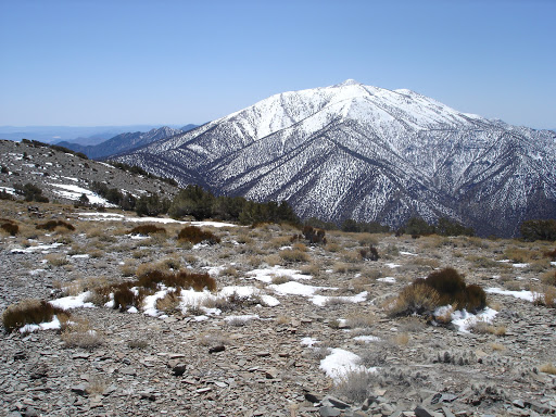
6. Telescope Peak trail Death Valley National Park
Telescope Peak is the highest point within Death Valley National Park, in the U.S. state of California. It is also the highest point of the Panamint Range, and lies in Inyo County. From atop this desert mountain one can see for over one hundred miles in many directions, including west to Mount Whitney, and east to Charleston Peak. The mountain was named for the great distance visible from the summit.
From Wikipedia, the free encyclopedia. -
7. Devil's Golf Course Death Valley National Park
The Devil's Golf Course is a large salt pan on the floor of Death Valley, located in the Mojave Desert within Death Valley National Park. The park is in eastern California. It was named after a line in the 1934 National Park Service guide book to Death Valley National Monument, which stated that Only the devil could play golf on its surface, due to a rough texture from the large halite salt crystal formations.
From Wikipedia, the free encyclopedia. -
10. Red Pass Death Valley National Park
The Sacramento River is the principal river of Northern California in the United States, and is the largest river in California. Rising in the Klamath Mountains, the river flows south for 400 miles before reaching the Sacramento–San Joaquin River Delta and San Francisco Bay. The river drains about 26,500 square miles in 19 California counties, mostly within the fertile agricultural region bounded by the Coast Ranges and Sierra Nevada known as the Sacramento Valley, but also extending as far as the volcanic plateaus of Northeastern California. Historically, its watershed has reached as far north as south-central Oregon where the now, primarily, endorheic Goose Lake rarely experiences southerly outflow into the Pit River, the most northerly tributary of the Sacramento. The Sacramento and i...
From Wikipedia, the free encyclopedia. -
11. Ubehebe Crater Death Valley National Park
Ubehebe Craters is a volcanic field in California. In northern Death Valley, it consists of up to 16 craters in a 3-square-kilometre area. The largest of these craters is the 800 metres wide and 235 metres deep Ubehebe Crater, but many of these craters are partially buried and thus poorly recognizable. Additional volcanic features present include a remnant of a scoria cone as well as a tuff cone. The Ubehebe Craters are associated with a fault system that runs across them. The region has been affected by volcanism for the last 10 million years. The volcanic field is part of the Death Valley National Park and is accessible to tourists. The fault system is within the tectonically active Basin and Range Province physiographic region Various estimates have been put forward for the age of the c...
From Wikipedia, the free encyclopedia. -
12. Golden Canyon Death Valley National Park
The Golden Gate National Recreation Area is a U.S. National Recreation Area protecting 82,027 acres of ecologically and historically significant landscapes surrounding the San Francisco Bay Area. Much of the park is land formerly used by the United States Army. GGNRA is managed by the National Park Service and is one of the most visited units of the National Park system in the United States, with more than 15 million visitors a year. It is also one of the largest urban parks in the world, with a size two-and-a-half times that of the consolidated city and county of San Francisco. The park is not one continuous locale, but rather a collection of areas that stretch from southern San Mateo County to northern Marin County, and includes several areas of San Francisco. The park is as diverse as i...
From Wikipedia, the free encyclopedia. -
13. Funeral Mountains Death Valley National Park
The Funeral Mountains are a short, arid mountain range in the United States along the California-Nevada border approximately 100 mi west of Las Vegas. The mountains are considered a subrange of the Amargosa Range that form the eastern wall of Death Valley. The crest of the range is within Death Valley National Park. The range is separated from the Grapevine Mountains to the northwest by the narrow Boundary Canyon and is separated from the Black Mountains by Furnace Creek Wash on the southwest and from the Greenwater Range at the narrow Travertine Point on the south. The broad flats of the Amargosa Desert lie across the border to the northeast in Nevada. The highest point in the range is Pyramid Peak, at 6703 ft .The first movement of Ferde Grofé's Death Valley Suite is a symphonic musical...
From Wikipedia, the free encyclopedia.


Death Valley National Park Videos
A Guide to Death Valley National Park
For more info about Death Valley National Park:To make reservation at Furnace Creek campgrounds:
Jeep Rentals:
Furnace Creek Resort:
Mesquite Flat Sand Dunes:
Zabriskie Point:
Dante’s View:
Artist’s Pallete:
Devil’s Golf Course:
Natural Bridge Canyon and other hiking spots:
Badwater Basin:
April L:
Carlos C:

7 Things to See in Death Valley with Kids
7 Things to See in Death Valley with KidsFor more detailed info see the TravelingMel blog post here:
See our bag review here:
Also check out if you want another desert park.
If you are looking for things to do and see in Death Valley National Park with Kids, here are 7 great things! This year is another Super Bloom year in Death Valley National Park in California. When the cold winds of winter are making you dream of warmer climates, Death Valley is a great place to visit with the family. Here are seven kid friendly sites to see in America's lowest national park from our visit in 2015 --a super bloom year.
More on Death Valley on the blog:
Death Valley with kids and families:
Almost home in Death Valley:
Music: Jukedeck
Subscribe for new videos:
Blog:
Instagram:
Facebook:
Filmmaking:
iphone 4s
Premiere Pro
From Wikipedia:
Death Valley National Park is an American national park that straddles the California—Nevada border, east of the Sierra Nevada. The park boundaries include Death Valley, the northern section of Panamint Valley, the southern section of Eureka Valley, and most of Saline Valley. The park occupies an interface zone between the arid Great Basin and Mojave deserts, protecting the northwest corner of the Mojave Desert and its diverse environment of salt-flats, sand dunes, badlands, valleys, canyons, and mountains. Death Valley is the largest national park in the lower 48 states, and the hottest, driest and lowest of all the national parks in the United States. The second-lowest point in the Western Hemisphere is in Badwater Basin, which is 282 feet (86 m) below sea level. Approximately 91% of the park is a designated wilderness area. The park is home to many species of plants and animals that have adapted to this harsh desert environment. Some examples include creosote bush, bighorn sheep, coyote, and the Death Valley pupfish, a survivor from much wetter times. UNESCO included Death Valley as the principal feature of its Mojave and Colorado Deserts Biosphere Reserve in 1984.
A series of Native American groups inhabited the area from as early as 7000 BC, most recently the Timbisha around 1000 AD who migrated between winter camps in the valleys and summer grounds in the mountains. A group of European-Americans, trapped in the valley in 1849 while looking for a shortcut to the gold fields of California, gave the valley its name, even though only one of their group died there. Several short-lived boom towns sprang up during the late 19th and early 20th centuries to mine gold and silver. The only long-term profitable ore to be mined was borax, which was transported out of the valley with twenty-mule teams. The valley later became the subject of books, radio programs, television series, and movies. Tourism expanded in the 1920s when resorts were built around Stovepipe Wells and Furnace Creek. Death Valley National Monument was declared in 1933 and the park was substantially expanded and became a national park in 1994.
The valley is actually a graben with the oldest rocks being extensively metamorphosed and at least 1.7 billion years old. Ancient, warm, shallow seas deposited marine sediments until rifting opened the Pacific Ocean. Additional sedimentation occurred until a subduction zone formed off the coast.
In 2013, Death Valley National Park was designated as a dark sky park by the International Dark-Sky Association.
death valley national park, death valley california, things to do in death valley, death valley for kids, death vally, death valley attractions, death valley kids, things to see in death valley, expedia death valley, death valley, death valley national park, california, mojave, nps, badwater, badwater basin, devil's golf course, dante's view, dante's view ridge, mt. perry, national park, desert, hiking, camping, backpacking, golden canyon, artist's drive, mesquite sand dunes, sand dunes, sunset, darwin falls, mosaic canyon, roadtrip, summit, mountains, geology, views, camping and hiking, travel, trail, stargazing, campfire, lizard, snake, artist's palette, , abandoned mines in death valley, death valley, abandoned mine, mines death valley, ran out of gas, abandon in desert, 100 years old, old abandon mines, blocked off, no trespassing, people that lived in caves, 100 year old mines, stranded in the desert, breaking into mine, trespassing, not allowed, exploring abandoned mines, abandon mine, funk bros, capron funk, corey funk, mine house, death valley national park best hikes, when did death valley become a national park, death valley backcountry camping, death valley trees, valley of fire, Nevada, valleyoffire, the wave, TravelingMel

Death Valley in 24 Hours: Exploring the Park's Best Hikes, Views & Photography Points
Death Valley in 24 Hours: Exploring the Park in 1 DayThis video shows you how to explore Death Valley National Park to the fullest in 24 hours. The park is so big and has so much to do that it can be daunting for the first time visitor. Doing the things laid out in this guide will help you to make the most of your time though.
Here are what we visit:
- Amargosa Opera House
- Dante's View
- Zabriskie's Point
- Furnace Creek Campground
- Corkscrew Saloon
- Mesquite Dunes
- Salt Creek Trail
- Visitors Center
- Golden Canyon
- Artist Palette
- Devil's Golf Course
- Natural Bridge
- Badwater
- Ashford Mill
Read more about it at
Music:
- Cielo - Huma-Huma
- Golden - Vibe Tracks

Death Valley National Park Road Trip - How You DON'T Want It To End
Death Valley National Park Road TripIf you're not a big fan of the heat, but want to know what it's like inside Death Valley, this Death Valley tour video might help. This is the road trip my friend and I took just before summer.
--
MY MAIN GEAR:
Camera Body -
GoPro HERO 4 Black -
Rode Mic -
Canon Lens-
Tokina Lens-
GlideCam Stabilizer -
Camera Bag -
Bobby's amazing camera -
--
Death Valley is one of the hottest places in the world. It’s also a short 4 hour drive away from Los Angeles. With summer approaching, I wanted to take a road trip out to Death Valley before it got too hot.
My friend Bobby went with me. Neither of us had been, yet. We were only there two days yet I’d say we did learn how to road trip Death Valley successfully by failing at a few things first.
Here are some basic tips to get you started:
Bring a hat, sunscreen, and lots of water. And make sure you are 100% confident in whatever car you are taking out there. The conditions are rough. There’s virtually no cell phone service and no relief from the sun if you get stranded. Also, Death Valley camping is a thing, but I suggesting you know what you're doing. Because we wanted to make things simple, we just stayed in a motel in Beatty, right outside the park.
As I said, we planned on making this road trip to Death Valley a simple one, but it turned out to be the opposite of that because of car trouble. I had to get my car towed. I’ll let the video explain that.
Here are some more tips if you’re traveling to Death Valley:
What to see when visiting Death Valley:
-Father Crowley Vista
-Rhyolite Ghost Town
-Mesquite Flat Sand Dunes
-Badwater Basin
-Devil’s Golf Course
-Artist’s Drive
-Artist’s Palette
-Zabriskie Point (I don't know for certain, but this seemed to be a popular Las Vegas to Death Valley tour route destination. It was super crowded with lots of tour buses and people pouring out.)
-Dante’s View
My favorites:
Badwater Basin, Mesquite Flat Sand Dunes, Artist’s Drive/Palette
Devil’s Golf Course was pretty cool too. But mainly just because it’s fun to walk on. It’s razor sharp though.
Also, If you road trip Death Valley, consider the car you bring because there are certain roads that are only good for high clearance vehicles. Most of top sights are all accessible via paved roads, but there are a few (like the Race Track) that aren’t.
Where to stay in Death Valley:
We stayed overnight in a town called Beatty. It’s right outside the east edge of Death Valley and much cheaper. There are also some town-like areas (used town very loosely) inside the park with hotels, cottages, and camp grounds. Consider staying in Furnace Creek, Stovepipe Wells, or Panamint Springs. If you're looking for hotels near Death Valley, you don't have many options. I'd say Lone Pine to the west and Beatty to the east are your best options. Death Valley camping sites can be found all over the park. But again, make sure you know what you're doing and go in a cooler month.
We went in May to beat the heat, but it didn’t work. Death Valley weather is crazy. It was 110 and 111 the days we were there. The week before the weather was in the 90’s. The NP website actually says May is usually when it starts getting too hot for visitors.
I hope you enjoy watching our Death Valley tour via video. It was definitely quite the experience.
Music by Lyvo
“Traveller”
Music by Joakim Karud
“Something New”
Act Three by Audionautix is licensed under a Creative Commons Attribution license (
Artist:
---------------
CONNECT with me:
- Facebook:
- Twitter:
- Instagram:
- Subscribe to this channel:
Road Trip Randy is a participant in the Amazon Services LLC Associates Program, an affiliate advertising program designed to provide a means for sites to earn advertising fees by advertising and linking to amazon.com.

Top 16. Best Tourist Attractions in Death Valley National Park
Top 16. Best Tourist Attractions and Things to Do in Death Valley National Park: Dante's View, Zabriskie Point, Badwater, Artist's Drive, Artists Palette, Mesquite Flat Sand Dunes, Mosaic Canyon, Furnace Creek Visitor Center, Furnace Creek, The Racetrack, Devil's Golf Course, Scotty's Castle, Salt Creek Interpretive Trail, Stovepipe Wells Village, Darwin Falls, Natural Bridge Canyon
THE BEST NATIONAL PARK - DEATH VALLEY (US)
-FREE $40 AIR-BNB CREDIT (Worldwide):-FREE $25 BOOKING.COM CREDIT (Worldwide):
CAMERA GEAR:
BACKPACKING GEAR:
In this video I went to Death Valley National Park in California. Probably the best national park I have ever been to and definitely the most unusual. This park has the most unique nature that I have ever seen.
LIKE & SUBSCRIBE!
Follow:
Music by:

Pahrump, Nevada To Death Valley National Park Itinerary
Pahrump, NV is our starting point in this one day Itinerary through Death Valley National Park. We will explore awe inspiring sunrises and mountains that soar over 11,000 feet. We'll pass through the historical town of Death Valley Junction on Route to Death Valley where we'll make stops at Dante's View, Zabriskie Point, Furnace Creek Ranch, Golden Canyon, Artist Palett to the lowest place in the western hemisphere, Badwater basin then make our way back to Pahrump. Your Base Camp To Adventure. CLICK ON THIS LINK TO SEE MORE VIDEO and explore what there is to see and do in Pahrump, NV.
5 Top-Rated Day Trips from Las Vegas, Nevada | the United States Day Tours Guide
5 Top-Rated Day Trips from Las Vegas, United StatesLas Vegas isn't the only place worth visiting in Nevada. This massive state is blessed with stunning landscapes and an incredible history offering fantastic opportunities to explore and discover natural attractions within easy reach of the big, glittering city. Head west to the towering spires of Red Rock Canyon or the magnificent landscapes of Death Valley National Park. A trip east of Las Vegas will take you to Boulder City and Lake Mead, the largest reservoir in the country, then head north from the lake to explore the stunning landscape of solidified ancient sand dunes in Valley of Fire State Park. Cap a day trip east of the city with the Lost City ruins near Overton. Here five day trips from Las Vegas, Nevada.
1. Death Valley National Park
2. Hoover Dam
3. Red Rock Canyon National Conservation Area
4. Lake Mead National Recreation Area
5. Valley of Fire State Park
GET MORE INFORMATION - Subscribe ➜
SHARE this Video: ➜
Also check another playlists..
Tourist Attraction in United States ➜
Tourist Attraction in America ➜
Tourist Attractions in Asia ➜
Tourist Attractions in Europe ➜
Tourist Attraction in Australia ➜
Backsound:
Source:
Sources images:

California Road Trip TRAVEL GUIDE | REDWOOD FOREST
What to do in CALIFORNIA | REDWOOD FOREST. In this California travel guide these are my top things to do in California while on a road trip starting in Northern California ending in SoCal!Huge thanks to Visit California for partnering with me on this travel series! Plan your own California road trip here!
Places visited in this video:
Santa Rosa, Sonoma Valley, Santa Cruz County, Safari West
Subscribe for more Travel Films! and turn on POST NOTIFICATIONS!
Follow Mike Sheffer:
Follow me:
Copyright Free Music I use!
Huge thanks to Camera Gear from B&H Photo:
Filmed, Edited and Produced By Erik Conover LLC, NYC 2018
#california #travel #travelguide

Top 10 most beautiful places and attractions in state California
best price Hotels -Top 10 most beautiful places and attractions in California: Napa Valley, death Valley, Los Angeles, Yosemite National Park, Sequoia National Park, Santa Catalina Island, Palm Springs, Santa Barbara, San Francisco, San Diego
Places in Death Valley National Park
Near By Places
-
Acampo
-
Acton
-
Adelanto
-
Agoura
-
Agoura Hills
-
Agua Dulce
-
Aguanga
-
Alameda
-
Albany
-
Allensworth
-
Alpine
-
Alta Loma
-
Altadena
-
Alturas
-
Alviso
-
Amador County
-
Amboy
-
Anderson
-
Antioch
-
Apple Valley
-
Aptos
-
Arvin
-
Atwater
-
Azusa
-
Bakersfield
-
Banning
-
Bass Lake
-
Bear Valley
-
Beaumont
-
Bell Gardens
-
Bellflower
-
Benicia
-
Berkeley
-
Big Bear Region
-
Big Sur
-
Bishop
-
Bodfish
-
Bonita
-
Boron
-
Borrego Springs
-
Boulder Creek
-
Brentwood
-
Bridgeport
-
Brooks
-
Buellton
-
Burbank
-
Burlingame
-
Burney
-
Butte City
-
Cabazon
-
Calabasas
-
Calaveras County
-
California City
-
California Desert
-
California Deserts
-
California Hot Springs
-
California's Central Valley
-
California’s Central Coast
-
Calipatria
-
Camarillo
-
Camino
-
Campbell
-
Campo
-
Capitola
-
Carlsbad
-
Carmel Valley
-
Carmichael
-
Carpinteria
-
Carson
-
Cassel
-
Castaic
-
Castella
-
Castro Valley
-
Catalina Island
-
Cerritos
-
Channel Islands National Park
-
Chico
-
China Lake
-
Chinese Camp
-
Chino
-
Chino Hills
-
Chowchilla
-
Chula Vista
-
Citrus Heights
-
City of Industry
-
Claremont
-
Clarksburg
-
Clayton
-
Coalinga
-
Coarsegold
-
Coloma
-
Colton
-
Columbia
-
Colusa
-
Compton
-
Coronado
-
Coulterville
-
Covina
-
Crescent City
-
Crestline
-
Culver City
-
Cupertino
-
Daly City
-
Dardanelle
-
Davis
-
Del Mar
-
Descanso
-
Dinuba
-
Dixon
-
Downey
-
Downieville
-
Dunlap
-
Dunsmuir
-
El Cajon
-
El Cerrito
-
El Dorado Hills
-
El Portal
-
El Segundo
-
El Sobrante
-
Elk Grove
-
Emeryville
-
Encinitas
-
Escondido
-
Exeter
-
Fair Play
-
Fairfield
-
Fall River Mills
-
Fallbrook
-
Fallen Leaf
-
Felton
-
Fillmore
-
Fish Camp
-
Folsom
-
Fontana
-
Foresthill
-
Foster City
-
Fremont
-
Fresno
-
Friant
-
Funner
-
Galt
-
Gardena
-
Gasquet
-
Georgetown
-
Gilroy
-
Glendora
-
Gold Country
-
Gold River
-
Goleta
-
Gorman
-
Grass Valley
-
Greenfield
-
Groveland
-
Guadalupe
-
Gustine
-
Hacienda Heights
-
Half Moon Bay
-
Hanford
-
Hathaway Pines
-
Hayward
-
Hemet
-
Hermosa Beach
-
Hesperia
-
High Sierra
-
Highland
-
Hilmar
-
Hiouchi
-
Hollister
-
Hope Valley
-
Humboldt County
-
Huntington Lake
-
Idyllwild
-
Imperial Beach
-
Independence
-
Inglewood
-
Irwindale
-
Isla Vista
-
Jacumba
-
Jamestown
-
Jamul
-
Jolon
-
Joshua Tree National Park
-
Julian
-
June Lake
-
Keene
-
Kernville
-
King City
-
Kingsburg
-
Klamath
-
Knights Ferry
-
La Canada Flintridge
-
La Honda
-
La Mesa
-
La Mirada
-
Lake Arrowhead
-
Lake Elsinore
-
Lake Hughes
-
Lake Isabella
-
Lake Tahoe (California)
-
Lakehead
-
Lakeside
-
Lassen Volcanic National Park
-
Lathrop
-
Lebec
-
Lee Vining
-
Lemon Cove
-
Lemon Grove
-
Lincoln
-
Lindsay
-
Littlerock
-
Llano
-
Lodi
-
Loma Linda
-
Lomita
-
Lompoc
-
Los Alamos
-
Los Altos
-
Los Altos Hills
-
Los Angeles
-
Los Angeles County
-
Los Banos
-
Los Gatos
-
Los Olivos
-
Lost Hills
-
Lotus
-
Lucerne Valley
-
Madera
-
Malibu
-
Mammoth Lakes
-
Manhattan Beach
-
Manteca
-
Maricopa
-
Marin County
-
Marina
-
Marina del Rey
-
Mariposa
-
Markleeville
-
Martinez
-
Marysville
-
Mc Farland
-
McCloud
-
Mendocino County
-
Menifee
-
Menlo Park
-
Merced
-
Millbrae
-
Milpitas
-
Mineral
-
Modesto
-
Monrovia
-
Montague
-
Montara
-
Montclair
-
Montebello
-
Montecito
-
Monterey County
-
Monterey Park
-
Moorpark
-
Moraga
-
Moreno Valley
-
Morgan Hill
-
Moss Beach
-
Moss Landing
-
Mount Baldy
-
Mount Hamilton
-
Mount Hermon
-
Mount Laguna
-
Mount Shasta
-
Mountain View
-
Murrieta
-
Napa Valley
-
National City
-
Nevada City
-
Newbury Park
-
Newhall
-
Norco
-
Norden
-
North Coast California
-
North Fork
-
North Highlands
-
Norwalk
-
Oak Glen
-
Oakdale
-
Oakhurst
-
Oceanside
-
Ojai
-
Old Station
-
Ontario
-
Orange County
-
Orcutt
-
Orinda
-
Orland
-
Oroville
-
Oxnard
-
Pacifica
-
Paicines
-
Pala
-
Palo Alto
-
Palomar Mountain
-
Palos Verdes Estates
-
Pasadena
-
Patterson
-
Pauma Valley
-
Pearblossom
-
Penn Valley
-
Perris
-
Pescadero
-
Phelan
-
Pittsburg
-
Placer County
-
Placerville
-
Pleasant Hill
-
Plumas County
-
Point Mugu
-
Pollock Pines
-
Pomona
-
Ponderosa
-
Port Hueneme
-
Porterville
-
Poway
-
Ramona
-
Rancho Cordova
-
Rancho Cucamonga
-
Rancho Murieta
-
Rancho Palos Verdes
-
Rancho Santa Fe
-
Red Bluff
-
Redding
-
Redlands
-
Redondo Beach
-
Redwood City
-
Redwood National Park
-
Richmond
-
Rio Vista
-
Ripon
-
Riverbank
-
Riverside
-
Rumsey
-
Running Springs
-
Sacramento
-
Salinas
-
San Bernardino
-
San Bruno
-
San Carlos
-
San Diego
-
San Diego County
-
San Dimas
-
San Francisco
-
San Gabriel
-
San Gregorio
-
San Jacinto
-
San Jose
-
San Juan Bautista
-
San Leandro
-
San Luis Obispo County
-
San Marcos
-
San Marino
-
San Martin
-
San Mateo
-
San Pablo
-
Santa Barbara
-
Santa Clara
-
Santa Clarita
-
Santa Cruz
-
Santa Maria
-
Santa Monica
-
Santa Nella
-
Santa Paula
-
Santa Ynez
-
Santa Ysabel
-
Santee
-
Saratoga
-
Scotts Valley
-
Sequoia and Kings Canyon National Park
-
Shafter
-
Shasta Cascade
-
Shasta Lake
-
Shaver Lake
-
Shingletown
-
Sierra City
-
Sierraville
-
Signal Hill
-
Simi Valley
-
Sloughhouse
-
Smith River
-
Soda Springs
-
Solana Beach
-
Solvang
-
Somerset
-
Somis
-
Sonoma County
-
Sonora
-
Soquel
-
South El Monte
-
South San Francisco
-
Spaulding
-
Stanford
-
Stirling City
-
Stockton
-
Suisun City
-
Summerland
-
Sunnyvale
-
Susanville
-
Taft
-
Tehachapi
-
Temecula
-
Temescal Valley
-
The Inland Empire
-
Thousand Oaks
-
Three Rivers
-
Topanga
-
Topaz
-
Torrance
-
Tracy
-
Traver
-
Tri-Valley
-
Trinity Center
-
Tulare
-
Tulelake
-
Turlock
-
Twain Harte
-
Twin Bridges
-
Union City
-
Upland
-
Vacaville
-
Vallejo
-
Valley Center
-
Ventura
-
Ventura County Coast
-
Victorville
-
Vina
-
Visalia
-
Vista
-
Walnut Creek
-
Walnut Grove
-
Warner Springs
-
Watsonville
-
Weaverville
-
Weed
-
West Covina
-
West Hollywood
-
West Sacramento
-
Westlake Village
-
Wheatland
-
Whiskeytown
-
Willows
-
Winters
-
Wofford Heights
-
Woodland
-
Woodside
-
Wrightwood
-
Yosemite National Park
-
Yreka
-
Yuba City
-
Yucaipa