This website uses cookies to ensure you get the best experience on our website. Learn more
The Best Attractions In Norddal Municipality
Norddal is a municipality in Møre og Romsdal county, Norway. It covers the easternmost part of the Sunnmøre region along the border with Oppland county. The municipal center of the municipality is the village of Sylte in the Valldalen valley. Norddal covers an area with several distinct valleys and villages: Eidsdal and Norddal in the south; Tafjord in the east; and Fjørå/Selboskarbygda and Sylte in the Valldalen valley in the north. Norwegian County Road 63 traverses the municipality from south to north, going through several tunnels in the mountains. The Heggur Tunnel connects the isolated village of Tafjord with the rest of the municipality. The...
Continue reading...
From Wikipedia, the free encyclopedia.
Continue reading...
From Wikipedia, the free encyclopedia.
The Best Attractions In Norddal Municipality
-
6. Liabygda Church Stranda
Liabygda Church is a parish church in Stranda Municipality in Møre og Romsdal county, Norway. It is located in the village of Liabygda, on the northern shore of the Norddalsfjorden. The church is part of the Liabygda parish in the Austre Sunnmøre deanery in the Diocese of Møre. The white, wooden church was built in 1917 by the architect Hans Buchner. The church seats about 165 people.
From Wikipedia, the free encyclopedia.


Norddal Municipality Videos

Beautiful Mountain Roads Of Norway | Der Trollstigen in Norwegen|Trollstigen Norway serpetine pass
Please SUBSCRIBE to my Youtube Channel KT Productions by clicking SUBSCRIBE button below to get more videos like this for free.Norway Geiranger - Trollstigen Road 63 - Driving Downhill
A part of the amazing 63 road (Calld Trollstigen) downhill run.
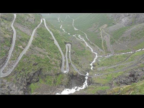
Trollstigen is a serpentine mountain road in Rauma Municipality, Møre og Romsdal county, Norway. It is part of Norwegian County Road 63 that connects the town of Åndalsnes in Rauma and the village of Valldal in Norddal Municipality. It is a popular tourist attraction due to its steep incline of 10% and eleven hairpin bends up a steep mountainside. During the top tourist season, about 2,500 vehicles pass daily. During the 2012 season, 161,421 vehicles traversed the route, compared to 155,230 vehicles during 2009.
Wikipedia Info:
Trollstigen (English: Trolls' Ladder) is a serpentine mountain road in Rauma, Norway, part of Norwegian National Road 63 connecting Åndalsnes in Rauma and Valldal in Norddal. It is a popular tourist attraction due to its steep incline of 9% and eleven hairpin bends up a steep mountain side. Trollstigen was opened on July 31, 1936, by King Haakon VII after 8 years of construction. During the top tourist season about 2,500 vehicles pass daily.[1][2]
The road is narrow with many sharp bends, and although several bends have been widened during the years 2005 to 2012,[3] vehicles over 12.4 metres long are prohibited from driving the road. During the 2011 and 2012 seasons buses up to 13.1 metres were temporarily allowed as a trial.[4][5] At the 700 metres plateau there is a car park and several viewing balconies overlooking the bends and the Stigfossen waterfall. Stigfossen falls 320 metres down the mountain side. The pass has an elevation of approximately 850 metres.
A major tourist facility including a museum was completed in 2012. Several viewing platforms have been constructed and older constructions improved upon. Trollstigen (along with road 63) was officially opened as a national tourist route by the Minister of Transport and Communications on June 16, 2012.[6] Trollstigen itself (and the alpine summits to the west) lies within the Trollstigen landscape protection area,[7] while the alpine area east of Trollstigen (notably Trolltindene range) is part of Reinheimen National Park.[8]
Trollstigen is closed during autumn and winter. A normal opening season stretches from mid-May to October, but may sometimes be shorter or longer due to changes in the weather conditions.
In the summer of 2005 the road was repaired and about 16 million NOK was spent on protection against rockfall, making the road safer to drive on.
नॉर्वे (यूरोप) के सूंदर पहाड़ी रास्ते
I created this video with the YouTube Video Editor (
#Europe#norway#scenes
The Trollstigen road (Norway/Norge)
(EN) Trollstigen is a serpentine mountain road in Rauma Municipality, Møre og Romsdal county, Norway.It is part of Norwegian County Road 63 that connects the town of Åndalsnes in Rauma and the village of Valldal in Norddal Municipality. It is a popular tourist attraction due to its steep incline of 10% and eleven hairpin bends up a steep mountainside. During the top tourist season, about 2,500 vehicles pass daily. During the 2012 season, 161,421 vehicles traversed the route, compared to 155,230 vehicles during 2009.
The road is narrow with many sharp bends, and although several bends were widened during 2005 to 2012, vehicles over 12.4 metres long are prohibited from driving the road. During the 2011 and 2012 seasons, buses up to 13.1 metres were temporarily allowed as a trial. At the 700-metre plateau there is a car park and several viewing balconies overlooking the bends and the Stigfossen waterfall. Stigfossen falls 320 metres down the mountainside. The pass has an elevation of approximately 850 metres
Trollstigen is closed during late autumn and winter. A normal operating season stretches from mid-May to October, but may sometimes be shorter or longer due to weather conditions.(Wikipedia)
Map of Travel:
VALPARD FILMS

Norway,Trolls Road by bus,dangerous road -Trip to Norwegian Fjords -part 27-Travel,calatorii,vlog
Trollstigen is a serpentine mountain road in Rauma Municipality.It is part of Norwegian County Road 63 that connects the town of Åndalsnes in Rauma and the village of Valldal in Norddal Municipality. It is a popular tourist attraction due to its steep incline of 10% and eleven hairpin bends up a steep mountainside. During the top tourist season, about 2,500 vehicles pass daily.
Trollstigen is closed during late autumn and winter. A normal operating season stretches from mid-May to October, but may sometimes be shorter or longer due to weather conditions.
My trip to the Norwegian Fjords with bus, through the following countries: Hungary, Slovakia, Poland, Lithuania, Latvia, Estonia, Finland, Sweden, Norway, Denmark, Germany, Czech Republic
Video by Constantin Florea
costiflorea1@yahoo.com

Norway l True Heaven l Waterfall l Campaign l Trekking l 1080p HD
Norway is True Heaven On Earth (Enjoy the moments)In June 2017 We travel to Norway.it was awesome experience to travel Norway ROAD TRIP
Norway is the land of the lean because of their healthy lifestyle. Although Norway is one of the richest countries in the world, Norwegians lead a simple but healthy life.For Scandinavia's most thrilling sightseeing, we sail under towering fjord cliffs, hike on powerful glaciers, and find surviving traditions in remote farm hamlets. Then we delve into the Hanseatic heritage and enjoy the salty hospitality of Norway's historic capital, Bergen
#Trolltunga
Trolltunga (Troll tongue) is a rock formation situated about 1,100 metres above sea level in the municipality of Odda in Hordaland county, Norway. The special cliff is jutting horizontally out from the mountain, into free air about 700 metres (2,300 ft) above the north side of the lake Ringedalsvatnet.[1]
#Preikestolen
Preikestolen or Prekestolen (English: Preacher's Pulpit or Pulpit Rock) is a famous tourist attraction in the municipality of Forsand in Rogaland county, Norway. Preikestolen is a steep cliff which rises 604 metres (1,982 ft) above the Lysefjorden. Atop the cliff, there is an almost flat top of approximately 25 by 25 metres (82 ft × 82 ft). It sits on the north side of the fjord, opposite the Kjerag plateau, located on the south side.
#Atlantic Ocean Road
The Atlantic Ocean Road or the Atlantic Road (Norwegian: Atlanterhavsveien) is an 8.3-kilometer (5.2 mi) long section of County Road 64 that runs through an archipelago in Eide and Averøy in Møre og Romsdal, Norway. It passes by Hustadvika, an unsheltered part of the Norwegian Sea, connecting the island of Averøy with the mainland and Romsdalshalvøya peninsula. It runs between the villages of Kårvåg on Averøy and Vevang in Eida. It is built on several small islands and skerries, which are connected by several causeways, viaducts and eight bridges—the most prominent being Storseisundet Bridge.
#Bergen
Bergen, historically Bjørgvin, is a city and municipality in Hordaland on the west coast of Norway. At the end of the first quarter of 2016, the municipality's population was 278,121,[1] and the Bergen metropolitan region has about 420,000 inhabitants. Bergen is the second-largest city in Norway.
#Trollstigen
Trollstigen (English: Trolls' Path[1]) is a serpentine mountain road in Rauma Municipality, Møre og Romsdal county, Norway.
It is part of Norwegian County Road 63 that connects the town of Åndalsnes in Rauma and the village of Valldal in Norddal Municipality. It is a popular tourist attraction due to its steep incline of 10% and eleven hairpin bends up a steep mountainside.
#Lofoten
Lofoten (Norwegian pronunciation: [ˈluːfuːtn̩]) is an archipelago and a traditional district in the county of Nordland, Norway. Lofoten is known for a distinctive scenery with dramatic mountains and peaks, open sea and sheltered bays, beaches and untouched lands. Though lying within the Arctic Circle, the archipelago experiences one of the world's largest elevated temperature anomalies relative to its high latitude.
#Røldal
Røldal is a village in the municipality of Odda in Hordaland county, Norway. The village lies in the Røldal valley along the Storelva river on the north end of the lake Røldalsvatnet.
#Kjeragbolten
Kjeragbolten is a boulder located on the mountain Kjerag in Forsand municipality in Rogaland county, Norway. The rock itself is a 5-cubic-metre (180 cu ft) glacial deposit wedged in the mountain's crevasse. It is a popular tourist destination and is accessible without any climbing equipment. However, it is suspended above a 984-metre (3,228 ft) deep abyss.
@pavan @keyur @mathew @dhiraj
Camera & accessories
Dji Mavic Pro#Hero Gopro5#Cannon mark 5d#iPhone 7+#iPhone 6#DjiOsmo
Edit in adobe premiere pro cc
Music: Credit goes 100% to one and only one my favourite Tony Anderson (album Breakthrough)

Norway - Trollstigen with fog/GoPro-amateur
Trollstigen (English: Trolls' Path) is a serpentine mountain road in Rauma Municipality, Møre og Romsdal county, Norway.It is part of Norwegian County Road 63 that connects the town of Åndalsnes in Rauma and the village of Valldal in Norddal Municipality. It is a popular tourist attraction due to its steep incline of 10% and eleven hairpin bends up a steep mountainside. During the top tourist season, about 2,500 vehicles pass daily. During the 2012 season, 161,421 vehicles traversed the route, compared to 155,230 vehicles during 2009.
The road is narrow with many sharp bends, and although several bends were widened during 2005 to 2012, vehicles over 12.4 metres (41 ft) long are prohibited from driving the road. During the 2011 and 2012 seasons, buses up to 13.1 metres (43 ft) were temporarily allowed as a trial. At the 700-metre (2,300 ft) plateau there is a car park and several viewing balconies overlooking the bends and the Stigfossen waterfall. Stigfossen falls 320 metres (1,050 ft) down the mountainside. The pass has an elevation of approximately 850 metres (2,790 ft).
Trollstigen is closed during late autumn and winter. A normal operating season stretches from mid-May to October, but may sometimes be shorter or longer due to weather conditions.
#POZOR #POZOR toto videjko je len druhá časť výletu z neďalekého severného Nórska. Na ďalších sa pracuje, ale notebook nestíha. V prípade, že by ste mi chceli prispieť na macbook, alebo poradiť nejakú alternatívu s OS Win do 1600€, hláste sa u pani Blážovej.
#zomri
#takzetak
Skladba Isolated od interpreta Kevin MacLeod je zahrnutá do licencie Creative Commons Attribution (
Zdroj:
Interpret:

The Fjords of Norway - World Heritage
UNESCO has included the fjords of Norway, exemplified by the Nærøyfjord and the Geirangerfjord, on its renowned World Heritage List. The Geirangerfjord and Nærøyfjord now enjoy the same recognition as the Great Wall of China, the Great Pyramids of Egypt, Zambias Victoria Falls and the Grand Canyon in USA.The west Norwegian fjords are classic, superbly developed fjords, considered as the type locality for fjord landscapes in the world. They are comparable in scale and quality to other existing fjords on the World Heritage List and are distinguished by the climate and geological setting.
The Naeroyfjord and the Geirangerfjord areas are considered to be among the most outstanding fjord areas on the planet. The Naeroyfjord is perhaps the most spectacular arm of the Sognefjord, and the narrowest fjord in the world, at on point only 250 metres across with mountains towering more than 1700 metres above its tranquil waters. The fjord area has been inhabited for about 10 000 years. The area has been farmed for almost 3000 years, and farming is still important for people living along the fjord.
The west Norwegian fjords are situated one on each side of the Jostedalsbreen Glacier and comprise of the municipalities of Aurland, Lærdal, Vik and Voss on the south side and the municipalities of Norddal and Stranda on the north side.

Seven most dangerous roads of the world
World's most dangerous roads top 7. Guoliang Tunnel, Los Caracoles Pass, Sichuan-Tibet Highway, Skippers Canyon Road, North Yungas Road, Karakoram Highway, Trollstigen.Details are given below for each road. (Please SUBSCRIBE our channel for more. Share and like the video. It helps a lot.)
Guoliang Tunnel
The Guoliang Tunnel is carved along the side of and through a mountain in China. The tunnel links the village of Guoliang to the outside through the Taihang Mountains which are situated in Huixian, Xinxiang, Henan Province of China.
Los Caracoles Pass
The Paso Internacional Los Libertadores, also called Cristo Redentor, is a mountain pass in the Andes between Argentina and Chile.
Sichuan-Tibet Highway
The Sichuan-Tibet Highway is a high-elevation road that begins in Chengdu of Sichuan on the east and ends at Lhasa in Tibet on the west. The road is 2,142km long. None-the-less it’s a regular route for truck drivers heading to the roof of the world.
The Sichuan-Tibet Highway, originally called the Kangding-Tibet Highway (a section of the No. 318 National Trunk Highway) takes you through vast, open landscapes with majestic peaks vaulting skyward. The plateau areas are dotted with castellated Tibetan homes and an infinite number of contentedly munching yaks. Travelers can enjoy the magnificent and changeable scenery ranging from warm spring to cold and snowing winter, which makes you intoxicated. This climate will be changing in front of you and you may think “days in heaven, but years on the earth”. The trip may take around 15 days if you you are not in a hurry. The Sichuan-Tibet Highway is also infamously known for bad driving surfaces and sharp mountain-side hairpins. Driving along single track sections in bad weather can be a great challenge to a less experienced driver.
Skippers Canyon Road
The Skippers Canyon Road, located in in the south-west of New Zealand's South Island, is today one of New Zealand's better known scenic roads and unbelievably scary as it’s totally narrow and different to manouvre your car. This gravel road, with a length of 16,5 miles, carved by hand by miners over 140 years ago is made from a very narrow cut in the middle of a sheer cliff face. It’s a road so dangerous that your rental car insurance won’t be honored if you drive on it.
The road was built during the gold rush, when a precarious pack track was the only access to Skippers township and the Upper Shotoverdiggings. Constructed between 1883 and 1890, the Skippers Road was considered a major engineering feat in its day. The miners who built the road in the late 1800s didn’t think much about luxury, though — it’s unpaved and very narrow. Should you encounter a car driving the other way, one of you will have to back up gingerly until you can find enough room to pass. Good luck figuring out which of you that will be. The road is so narrow that if two vehicles have to pass each other, one vehicle might have to reverse for anything up to 3 kilometres of winding narrow road to get to a place wide enough to pass. It’s one of only two roads in the country where rental car insurance is not honoured if driven on. Skippers Road is mostly one-way, narrow and steep with sheer drops of several hundred metres.
North Yungas Road
The North Yungas Road is a road leading from La Paz to Coroico, 56 kilometres northeast of La Paz in the Yungas region of Bolivia. In 1995 the Inter-American Development Bank named it as the world's most dangerous road.
Karakoram Highway
The N-35 or National Highway 35, known more popularly as the Karakoram Highway and China-Pakistan Friendship Highway, is a 1300 km national highway in Pakistan which extends from Hasan Abdal in Punjab.
The Karakoram Highway (known informally as the KKH) is said to be the highest paved international road in the world, but at its peak at the China-Pakistan border it is only paved on the Chinese side. It's the road to paradise – if you like exploring the mountains, that is. It's regarded as one of the world's hardest alpine climbs
The Karakorum Highway connects China and Pakistan across the Karakoram mountain range, through the Khunjerab Pass, at an elevation of 4,693 metres (15,397 ft) above the sea level. The road is one of the scariest and hair raising jeep trip in the world. 810 Pakistani and 82 Chinese workers lost their lives, mostly in landslides and falls, while building the highway. The route of the KKH traces one of the many paths of the ancient Silk Road.The road has a length of 1,300 km (800 mi): Pakistan: 887 km (551 mi) and China: 413 km (257 mi). it was started in 1959 and was completed in 1986 after 27 years of construction.
Trollstigen
Trollstigen is a serpentine mountain road in Rauma Municipality, Møre og Romsdal county, Norway. It is part of Norwegian County Road 63 that connects the town of Åndalsnes in Rauma and the village of Valldal in Norddal Municipality.
Near By Places
-
Alesund
-
Aukra Municipality
-
Averoy Municipality
-
Eide Municipality
-
Fraena Municipality
-
Giske Municipality
-
Halsa Municipality
-
Haram Municipality
-
Hareid
-
Kristiansund
-
Lauvstad
-
Midsund Municipality
-
Molde
-
Nesset Municipality
-
Orskog Municipality
-
Orsta
-
Rauma Municipality
-
Rindal Municipality
-
Sandoy Municipality
-
Smola Municipality
-
Stordal Municipality
-
Stranda
-
Sula Municipality
-
Sunndal Municipality
-
Surnadal Municipality
-
Sykkylven Municipality
-
Tingvoll Municipality
-
Ulstein Municipality
-
Vanylven Municipality
-
Vestnes Municipality
-
Volda